Hands-On Experiments Related to Tropical Cyclones
Part I: Evaporation, Condensation, and Wind
Is hurricane rainfall salty?

Equipment:
- large bowl or container filled with warm water
- salt
- empty ceramic cup or cup heavy enough to remain in place
- plastic wrap
- rubber band or tape to ensure plastic wrap seals tightly
It is the evaporation of ocean water that fuels the thunderstorms which comprise a hurricane. When a lot of energy is present in water, some of that energy is used to change the phase of water from a liquid to a gas, while the rest of the excess energy is used to speed up molecular motion and make the water warmer. Using energy to change the phase of a substance is called latent heat exchange, while using energy to alter the rate of molecular motion is called sensible heat exchange.
Once water from the ocean’s surface is evaporated, it gets lifted upwards into the atmosphere where it loses energy and its temperature drops. Condensation can then take place when the air can no longer accommodate the amount of water vapor it contains. When water vapor returns to liquid, clouds can form and precipitation can occur.
Question: Given that ocean water is salty, and it is this water that evaporates to form clouds and precipitation within hurricanes, will the rain that falls from a hurricane also be salty?
Method:
- Fill the bowl/container with warm water and add salt.
- Place the empty cup in the center of the bowl.
- Cover the bowl/container with plastic wrap and secure the edges with tape or a rubber band to form an airtight seal.
- Place the container in the sun, or apply heat to the container so that energy is added to the system to encourage evaporation.
- To ensure that condensation collects into the cup, place a small weight directly over the cup on top of the plastic wrap so that it slopes downward like a funnel.
- Taste the water in the cup to determine if it is salty or not.
When water evaporates, other substances within the liquid such as salt or pieces of dirt are left behind. So the water vapor that is ascending into the hurricane to help cloud formation is free of salt (although the air may contain salt and grains of dust that are blown about by the strong winds). This is why heavy rainfall produced by a hurricane is referred to as fresh water flooding. In contrast, storm surges cause salty ocean water to push inland beyond the normal high tide mark, so this would be an example of salt water flooding.
This experiment also demonstrates the processes of evaporation and condensation. At first, liquid water evaporates into the air inside the container. However, these water vapor molecules exert a pressure within the air column. When the maximum pressure that can be exerted in the air column is reached, evaporation can no longer occur. Saturation has been achieved and the air and dew point temperature are equal, and relative humidity is 100%. Some of the water vapor must condense back into a liquid. When enough condensation has taken place, the liquid droplets grow large enough to combine together and fall from the surface of the plastic or down the sides of the bowl. This grown process also occurs in clouds. Cloud droplets are different sizes and alone, they are so small that the uplifted air keeps them aloft. But when the bump into each other, they coalesce into larger droplets until they are heavy enough to fall towards the Earth’s surface. This process of rain drop growth is referred to as collision-coalescence and will happen within clouds as long as the air temperature is above freezing and water vapor continues to condensate into liquid droplets.
Part II: How hurricanes evaporate water vapor from the ocean’s surface

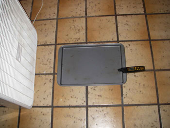
Figure 1. Setup of Part II experiment
Equipment:
- large tray/pan to hold warm water (the water will need to be filled up to the edge)
- warm water
- electric fan
- instrument to measure humidity (Note: A temperature/humidity pen from AmbientWeather.com works well and is easy to use. They are available for $40-$60.)
Method:
- Set up the empty tray on a large table.
- Set the fan up on one side of the tray, but do not turn it on yet.
- Take a humidity measurement just above the empty tray.
- Take a humidity measurement 2-3 feet "downwind" of the empty tray.
- Fill the tray with warm water, but do not turn on the fan yet.
- Repeat humidity measurements above and downwind of the tray.
- Turn on the fan.
- Repeat humidity measurements above and downwind of the tray over several minutes. (Note: When moving the sensor to a different location, you may need to wait a minute or more for it to adjust to the new environment.)
We saw in Part I that when liquid water is placed in a closed container, that the processes of evaporation and condensation will take place simultaneously once the air becomes saturated. If you were to remove the plastic covering, the water vapor molecules could be slowly pushed upwards into the air outside of the container. This would decrease the pressure at the water’s surface and allow more evaporation to take place without the air column reaching saturation. However, if we use wind to carry away the water vapor molecules from above the water’s surface, even more evaporation can now take place.
Setting up the equipment and taking readings before adding water establishes the baseline conditions. The room where the experiment is conducted may have different air temperature and humidity characteristics than another room nearby. Once warm water is added to the tray, water will begin to evaporate into the air and the humidity measurement just above the water’s surface will immediately begin to rise. This rise will not be immediately experienced a foot or two away from the water if the air is still.
Once the fan is turned on, humidity levels above the water surface will drop. This is because the water vapor that is now in the air right above the liquid water is being advected, or moved horizontally away from, its original location. The humidity at the downwind location should rise slightly. Depending on the scale of the room, the temperature and amount of moisture already present in the room, and the scale of the water source and fan, humidity may not rise very much at the downwind location. A thin layer of moist air is being spread out over a wide area as it travels further from the tray. But imagine 75 mph winds blowing over the vast ocean’s surface - that moving air carries water vapor up into the atmosphere, where it condenses to form clouds and precipitation.
Part III - The Coriolis Force
Students will gain first hand experience on how they must adjust their motion when located atop a spinning platform.

Equipment:
- medium-sized rubber-coated ball (for safety)
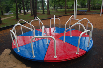
- merry-go-round
Coriolis force exists because the Earth is rotating about its axis. Depending on where you are located on the Earth’s surface, you experience a portion of this rotation. If you are located at one of the poles, you experience 100% of this force because you are aligned parallel to the axis of rotation. If you are located at the equator, you do not experience any of this effect because you are oriented perpendicular to the axis of rotation. Thus, Coriolis force varies with latitude.
If looking down on the North Pole from space, the Earth rotates counter-clockwise. This direction of rotation causes objects and the atmosphere to be deflected towards the right. This frame of reference is reversed in the southern hemisphere so that deflection is to the left because the axis of rotation is moving clockwise.
To simulate the Coriolis effect on a scale that humans can witness as they stand on the ground, a spinning platform is required. Tossing a ball back and forth represents an object that is moving but is unattached to the spinning platform, representing an airplane or gust of wind relative to the Earth’s surface.
Method:
- Students should board the merry-go-round with the ball.
- The person holding the ball should pass the ball straight towards their intended target. The platform is not moving yet.
- The target should be able to catch the ball easily.
- Return the ball to the original person.
- Have someone push the merry-go-round so that it begins to rotate in a counter-clockwise direction.
- The person holding the ball should pass the ball straight towards their intended target.
- The ball will move along a straight path, as it did originally when the platform was not moving.
- The target, however, will have to stretch to one side to try and catch the ball, or may not be able to reach it at all depending on how fast the platform is moving.
- Try to throw the ball again, but have the person aim ahead of where the target is currently located.
- Repeat until the thrower learns how far ahead they must aim to that the target receives the ball.
- Reverse direction of the rotation to clockwise and note that the target must reach off to the opposite side to retrieve the ball.
When the thrower aims the ball towards their target, they are aiming in the direction that the target is currently located. If the platform does not move, this direction does not change. However, if the platform moves, the target will be in a new location by the time the ball reaches their previous location. When the platform is rotating counter-clockwise, the ball will end up behind its intended target (to the right). When the platform is rotating clockwise, the ball will end up behind its intended target (to the left). In order for airplanes to land at the appropriate location, they must correct their trajectory. But winds cannot make a correction, so they are deflected right or left depending on which hemisphere they occur in.
An animation of this exercise is available at Oregon State University and The Bay Area Earth Science Institute.