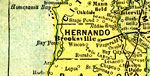
Hernando
County Maps
(Benton County, 1844-1850)
Click
on a thumbnail image to view a full size version of that map.
Hernando
County is Florida's 22nd county, established on February 24, 1843,
from segments of Hillsborough County,
Mosquito County, and Alachua
County. It is one of two counties that gains its name from Hernando de
Soto, a famous Spanish explorer. From March 6, 1844, till December 24, 1850,
the county was renamed Benton in honor of Thomas Hart Benton. He gained this
honor for sponsoring the Armed Occupation Act of 1842, which was favored by
Floridians wanting to evict the Native Americans. He later fell out of favor
and the name was changed back to Hernando. Brooksville is the county seat.
For earlier
maps of this area, visit the Hillsborough
County, Mosquito County, and Alachua
County map galleries.
Record
1 to
25 of
94
|
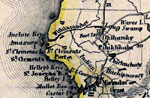
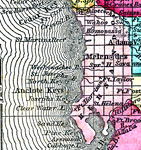
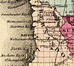
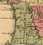
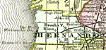
Hernando County,
1845
Meyer's 1845 map of Florida is derived from the Tanner/Mitchell Universal atlas map of 1839. This detail of that map covers Hernando County, which was called Benton County between 1844 and 1850. However, this map shows it named as Dade County. Routes...
|
|
Hernando County,
1850
Meyer's 1850 map of Florida is derived from the Tanner/Mitchell Universal atlas map of 1839, and similar to the 1845 maps. In this updated detail of Benton County, now Hernando County, waterways and townships are noted. Major features are Fort Izard,...
|
|
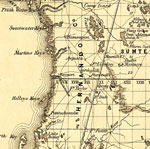
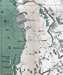
Benton County,
1850
This detail of a 1850 map from the New Universal Atlas shows towns, forts, roads, canals, major rivers and lakes in Benton County. The map is very similar to the 1839 map from Tanner's Universal Atlas. There are references to forts, battlefields, an...
|
|
Hernando County,
1856
This detail of a map from the annual report of the Surveyor General in 1856 shows Hernando County. Drainage, cities and towns, roads, trails, and location of railroad lines are shown in great detail. The major water features of the area are the Withl...
|
|
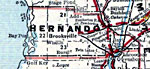
Hernando County,
1857
A map of Hernando County as of 1857 showing towns, forts, wetlands, bodies of water, and the county seat....
|
|
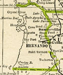
Hernando County,
1859
Railroad map of Hernando County, Florida showing river drainage, cities and towns, roads, and railroads in 1859. Several U.S. Forts are shown as well as the site of Major Dade s Massacre (1835- Second Seminole War). Township grids based on the Tallah...
|
|
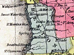
Hernando County,
1860
A map of Hernando County as of 1860 showing towns, the county seat, and rivers....
|
|
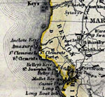
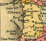
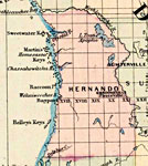
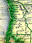
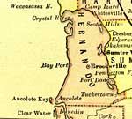
Hernando County,
1860
Map of Hernando County, showin Springhill, Pierceville, Bayport, Ft. Taylor, Augusta, Homosassa, Anclote Keys, and Chrystal, Homosassa, Chashowitska, Wechivachee rivers....
|
|
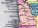
Hernando County,
1863
This detail of a map of Florida was "Entered according to Act of Congress in the year 1863 by A. J. Johnson in the clerks office of the District Court of the United States for the Southern District of New York." It shows Hernando County in ...
|
|
Hernando County,
1865
This detail of a map of Florida shows topographical information for Hernando County in 1865. Swampland is depicted in thin horizontal lines. Rivers are colored in blue while lakes and ponds are colored with green. Railroads, roads, and towns are also...
|
|
Hernando County,
1871
This 1871 detail of Florida shows county lines and county seats current to the period, major towns and cities, and railroad routes and stations for Hernando County. The major water features of this detail are the Withlacoochee River and the Crystal R...
|
|
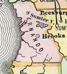
Hernando County,
1873
This detail of a 1873 map of Florida, Georgia, and South Carolina shows an in color portrait of county lines of the period, Florida railroad routes, forts, and outlines major waterways for Hernando County. The major water features of the detail are t...
|
|
Hernando County,
1874
This detail of a map of Florida indicates Hernando County current to 1874. It shows drainage, township and county boundaries, cities and towns, battlefields, and submarine cables to Havana. It also lists operating and newly chartered railroads of the...
|
|
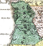
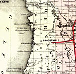
Hernando County,
1880
This map of Hernando County shows the county seat (Brooksville), forts, and cities current to 1880....
|
|
Hernando County,
1880
A map of Hernando County showing county lines, the county seat (Brooksville), and cities current to the 1880s....
|
|
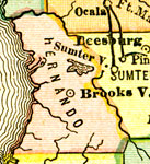
Hernando County,
1882
This detail of a map of Florida covers Hernando County and vicinity and indicates drainage, cities and towns, township and county boundaries, railroads, and the 15-mile railroad land grant limits surrounding the track. The major water features of the...
|
|
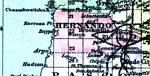
Hernando County,
1883
A map of Hernando County showing county lines, including the county seat (Brooksville)....
|
|
Hernando County,
1883
Digitization provided by the USF Libraries Digitization Center. This Hernando County map is from Poor s railroad map of Florida, circa 1883. It shows railroads, counties and county seats, cities and towns and inland waters. Approximate map scale is 7...
|
|
Hernando County,
1886
A map of Hernando County showing county lines, the county seat (Brooksville), and railroads connecting the major cities current to 1886....
|
|
Hernando County,
1886
This is a detailed map of Hernando County, Florida showing the County Seat, major cities, roads, railroads, inland waters, etc. Township and range grid established from the Tallahassee baseline and meridian shows the extent of land survey in the coun...
|
|
Hernando County,
1888
A map of Hernando County showing county lines, the county seat (Brooksville), railroads, and cities current to 1888....
|
|
Hernando County,
1888
This detail shows county lines and county seats current to the period, major towns and cities, and railroad routes and stations for Hernando County. The Townships are subdivided into sections, and those sections offered for sale by the land departmen...
|
|
Hernando County,
1888
This detail of a map of Florida indicates Hernando County current to 1888. The map was issued by the Florida Southern Railway Company. It shows lands, owned, and offered for sale by said department. Six square miles makes up a township, which is numb...
|
|
Hernando County,
1889
This is a detail of a map of Florida showing counties, railroads, cities, inland waters, etc for Hernando County. Each color represents a different route. The origin and destination for each route is found on the main map in an Explanation key. Featu...
|
|
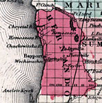
Hernando County,
1890
A map of Hernando County showing towns, bodies of water, county lines, the county seat (Brooksville), and railroads connecting the major cities current to 1890. ...
|
Maps ETC
is a part of the
Educational Technology Clearinghouse
Produced by the
Florida Center for Instructional Technology
© 2007
College of Education
,
University of South Florida